Summary of HMAS Sydney (II) and Kormoran - Lifeboat Workshop
RAN History - Archives
Summary of HMAS Sydney (II) AND Kormoran - Lifeboat Workshop 23-24 April 2003
The following is a summary of the findings of a Lifeboat Workshop undertaken on behalf of the Sea Power Centre - Australia during the period 23-24 April 03.
The views expressed in the summary are those of the authors and not necessarily those of the Royal Australian Navy. The conclusion represents one of a number of possible outcomes using applied meteorological and oceanographic data.
Background
Following a letter from LTCOL Warren Whittaker, OBE (Rtd) dated 11 January 2003 that related to a new analysis of the voyage of the Kormoran lifeboat, DSPC-A received CN approval to conduct an in-house analysis of navigational drift data. To this end, a workshop was held at the SPC-A on 23-24 Apr 03 by a panel of four RAN experts to evaluate the Whittaker theory. A supplementary activity was conducted at the SPC-A on 22 May 03 to apply the workshop data to the movement of additional drift objects. This minute provides a summary of the workshop analysis.
Lifeboat Workshop
The following personnel formed the expert panel conducting the navigational analysis:
- LCDR Darren Johnstone, Fleet Navigator, MHQ Australia ;
- LCDR Jim Crouch, meteorologist, RAN Hydrographic Office;
- LCDR John Cowan, Commanding Officer STS Young Endeavour; and
- LCDR Paul O'Driscoll, navigator, SO IT POL, DNISREW.
In addition to their professional experience, LCDR Johnstone and LCDR Cowan have extensive experience in oceanic and small boat sailing. LCDR Cowan also has experience in sailing the 27' RCN pattern whaler, a boat of similar characteristics to the Kormoran lifeboat.
Methodology
The panel determined that the best way of conducting the lifeboat analysis was to:
- take the landing point of the Meyer's lifeboat at Red Bluff,
- apply the known meteorological and oceanographic data during the voyage as sourced from Bureau of Meteorology records for November 1941, and
- work backward using navigational data from the lifeboat diary kept by LCDR Meyers, the Navigating Officer of Kormoran.
The diary kept by Meyers was cross-referenced to the diary of LEUT Von Malapert, the Communications Officer. There is some difference between the detail of the two, although the general accounts are generally in agreement. Unfortunately, since Meyer's diary was kept on the back of photographs, the detail is somewhat sparse. In particular, the data for 21-22 Nov is scanty and contradictory, which makes accurate reconstruction of the navigational component of the voyage virtually impossible. A best estimate is all that can be garnered from the limited data set.
Four components were included in the analysis:
- Wind driven current. Assumed as 4% of wind strength, 45 degrees to the left of the surface wind.
- Oceanic current. As specified in Chart Aus 416, the Australian Pilot and the routing chart.
- Leeway. Assumed as 3% of wind speed in a beam reach and 2% when close hauled or on a broad reach.
- Boat movements. Course steered as given in the Meyer's diary, with no account for variation or deviation.
Although examination of photographs does not indicate the lifeboat possessed a centreboard, the AMSA standard data for leeway on a flat bottom boat was not used because the boat was significantly over-loaded, with 62 men aboard, and as such the hull of the boat itself provided significant directional stability. This assumption ensured that the workshop analysis would have a different outcome to Whittaker's, as he applied leeway data based on a sailing dinghy with no centreboard and no more than two crew, which would have been significantly more affected by leeway.
While Whittaker used averaged data for wind speed, drift and current, the workshop used six-hourly data as provided by the Bureau of Meteorology for the period in 1941. Additionally, Whittaker does not appear to have taken into account the effect of the Leeuwin Current, which exerts a southerly influence. The workshop analysis incorporated the effect of this current in the analysis. Current data is sourced from chart Aus 416 and the Australian Pilot for the area.
Additional Activity
Due to time constraints, the workshop was only able to analyse the movement of the Meyers lifeboat and a German lifebelt picked up on 28 Nov 41. In order to obtain additional support for the theorised position, on 22 May 03 LCDR O'Driscoll applied the workshop data to the Kormoran life rafts recovered by HMT Aquitania and MV Trocas on 23-24 Nov 41.
Similar analytical premises as those assumed at paragraph 6 were applied to drift objects such as lifebelts and liferafts. The boat movement component was omitted as non-steerable flotsam would be subject to environmental influences alone. Leeway data was sourced from AMSA tables, assuming an inflatable liferaft with no canopy, giving 3% leeway. Calculations were also made for 5% leeway to give a greater margin for error.
The workshop data was not applied to the Kormoran lifeboats recovered by MV Koolinda and HMAS Yandra on 26-27 Nov 41, as no voyage data similar to that of Meyers/Malapert was available to add to the general environmental effects applied to the liferafts. Application of general environmental effects alone, without voyage data, would have placed the origin of the lifeboats inland. However, the final position of the two lifeboats was generally consistent with that of Meyers' lifeboat at Red Bluff.
Findings
The findings of the workshop suggest that previous hindcasting analyses have failed to take into account both oceanic current and wind-driven current, thereby underestimating the distance travelled by the Kormoran lifeboats and liferafts. However, the workshop members concluded that Whittaker had likely overestimated the degree of drift of the Meyers lifeboat, particularly through the amount of leeway attributed to a lack of a centreboard in the lifeboat. While a lightly loaded sailing boat missing its centreboard is subject to considerable leeway, the gross overloading of the lifeboat would have significantly reduced this effect.
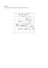
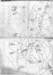
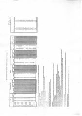
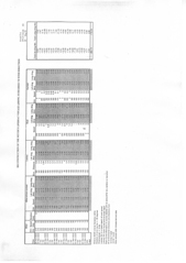
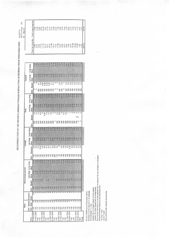
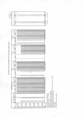
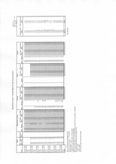
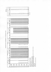
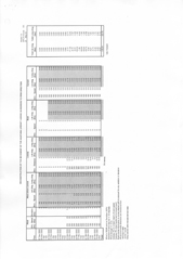
On balance of probability, the workshop determined that the journey of the Meyer lifeboat began in the vicinity of 28 01.5S 112 06.5E. This position lies between the 'official' position given by Detmers at 26S 111E and the position at 28 38'S, 113 22'E put forward by Whittaker. A map showing the three positions and the reconstructed voyage of the lifeboat is provided at Annex A. An extract of Chart Aus 416, showing the recovery positions and posited start locations of the lifeboats and drift objects, is at Annex B. The analytical data for the lifeboat voyage reconstruction is given at Annex C. Annex D and Annex E show the starting points based on analyses adding or subtracting 30 degrees respectively to and from the wind direction, to give an indication of maximum possible variation.
Based on the assumptions made, the workshop concluded that while the Whittaker position could not be ruled out, it was unlikely to be the starting point of the lifeboat voyage. Had the journey started at this point it is likely that the lifeboat would have made landfall much further south and sooner than 25 Nov 41.
A cursory analysis of the movement of Kormoran lifebelt recovered on 28 Nov 41 supports the feasibility of the workshop position. This analysis is provided at Annex G.
The same data as used for the lifebelt was applied to the liferafts recovered by Trocas and Aquitania. The analysis is provided at Annex H. The starting position of the liferafts is generally consistent with that of the Meyers lifeboat as determined by the workshop. It should be noted that the survivors on the liferafts reported having jury-rigged sails out of blankets. No account was taken in the analysis of any effects of these sails, the hindcasting being restricted to environmental effects alone. Were the effects of the sails to be taken into account, the starting position of the liferafts is likely to have been slightly further southeast, closer to the proposed starting position of the Meyer lifeboat. Unlike the lifeboat analysis, the addition of 30 degrees to the wind direction made no significant different to the start position of the liferaft. The data for this analysis is provided at Annex I.
Although not expert statisticians, the workshop concluded that, based on the limited lifeboat voyage data set, a 30% error of the total distance, up to 80nm from the derived position, could be accepted. This error is more likely to be southerly and westerly, which would take the derived position further away from either the Detmers or Whittaker positions.
Taking the 30% error margin, overlapping circles were drawn from the theorised 3% and 5% leeway starting positions of the drift objects and the theorised Meyer lifeboat start position. The circles overlapped in an oval area roughly bounded by the positions 27 12'S and 27 52'S and 111 05'E and 111 55' E. This is some 80nm south-east of the position given by Detmers as the battle site and 30nm north-east of the Meyer lifeboat start position as determined by the workshop. Within this area is the most likely location for the site of the battle between Sydney and Kormoran. Annex B provides an illustration of this area. Note that none of the 30% error circles overlapped the Detmers position, although the 3% leeway circle for the Aquitania liferaft was within 2nm of its most northerly limit.
Conclusions
Analysis of the lifeboat voyage by the workshop panel suggests that the correct site of the battle between Sydney and Kormoran lies between the Whittaker and Detmers positions. However, given the paucity of information from the lifeboat log, limited meteorological data from November 1941, and unclear data on the handling characteristics of the lifeboat, the actual position of the battle cannot be narrowed sufficiently to confidently suggest the resting place of the Kormoran wreck. For these reasons also the Detmers and the Whittaker positions cannot be definitively ruled out at this time.
Analysis of the drift of non-steerable objects such as the Kormoran liferafts and lifebelt generally supports the starting point of the Meyer lifeboat as determined by the workshop. However, since the workshop members were not experts on the movement of non-steerable flotsam it would be useful to verify these findings using an existing analytical computer model.
In the absence of any new evidence from archival sources or Kormoran survivors, there is little prospect of further limiting the potential search area for the wrecks of Sydney and Kormoran. Unless compelling new evidence comes to light, the mystery must await further advances in deep wreck location technology.

